
-High-Quality")
Knowledge makes an angler. More than luck, it is knowledge that guarantees an epic fishing trip. Most anglers have good knowledge of their own fisheries. Being able to cross-reference their knowledge regarding fish behaviour for each weather type with all the available technology including a barometer on the market will not only save you time but also catch you more fish.
The ‘best times’ for fishing
Most anglers will jump at the chance to go for a fish when it’s only blowing 5/10 knots, Unfortunately, wind is not the only thing that is going to affect your fishing. There are other elements that need to be looked into, to have successful fishing trips, instead of just relying on luck.
That being said, having a better understanding of these five weather factors can turn what could have been a hard day’s fishing into a very successful day on the water.
Environmental factors that could change the way you fish
To make use of these elements better, we will try to explore the influence of each to the way the fish behaves. As we learn more about the things that make a fish tick (or tock), we hope you can make the most of your trip and avoid going home feeling a little humbled by the day out. We also added in a few tips, which you might find useful as you plan your next trip.
Barometric pressure

As a fishing guide, I always hear the expression, “1020 fish a plenty.” You’ve probably heard it, too, if you’ve been fishing for quite some time. In case you haven’t, this is an expression, almost like an unofficial ‘rule’ that tells anglers that fish feed when the barometric pressure on the barometer goes above the normal medium of 1012 hectopascals (hPa) to 1015 hPa on a good day.
Whether you think about this phenomenon scientifically or you attribute this fish feeding frenzy to some other mythical reasons is up to you. As a fishing guide, what makes the most sense to me is that it has something to do with how the earth’s high/low atmospheric pressure affects the pressure in the water, and consequently, the air bladders of the fish.
There are many online resources detailing this, but I think a lot of people do not really understand it. So, let’s make it simple.
Barometric pressure, otherwise known as atmospheric pressure or air pressure, is the weight of air. It presses on everything, including fish and anglers.
When the barometric pressure is low, it measures at around 1012 hPa or lower on the barometer. At this level, the fish closer to the water surface feel less pressure on their air bladder, causing their air bladder to expand and fill their stomach causing the fish to go off the bite. When it happens, the fish go deeper into the water column where there is more pressure on their bladder. It causes them to move, and consequently, to feed.
When the atmospheric or barometric pressure is at 1015 hPa and above on the barometer, there is more pressure on the air bladder of the fish in top water, which keeps them moving, thus leaving them with empty stomachs. That said, they are more likely to feed in the top of the water column, giving you, the angler, a better chance for a top water hit.
This is also why sharks can eat regardless of atmospheric pressure. Since they have pectoral fins instead of swim bladders, they can go up and down like a plane without feeling the pressure. That said, they can feed whenever and wherever, too.
Barometer Expert tip: Fishing with a rising or falling barometer is fine. But, when there’s low pressure, it’s best to go in deeper water, jig more, and drop live or dead baits to target prime feeding fish.
RELATED: Simrad NSS EVO3 Review: Why a Sounder is a Must When Angling
Currents
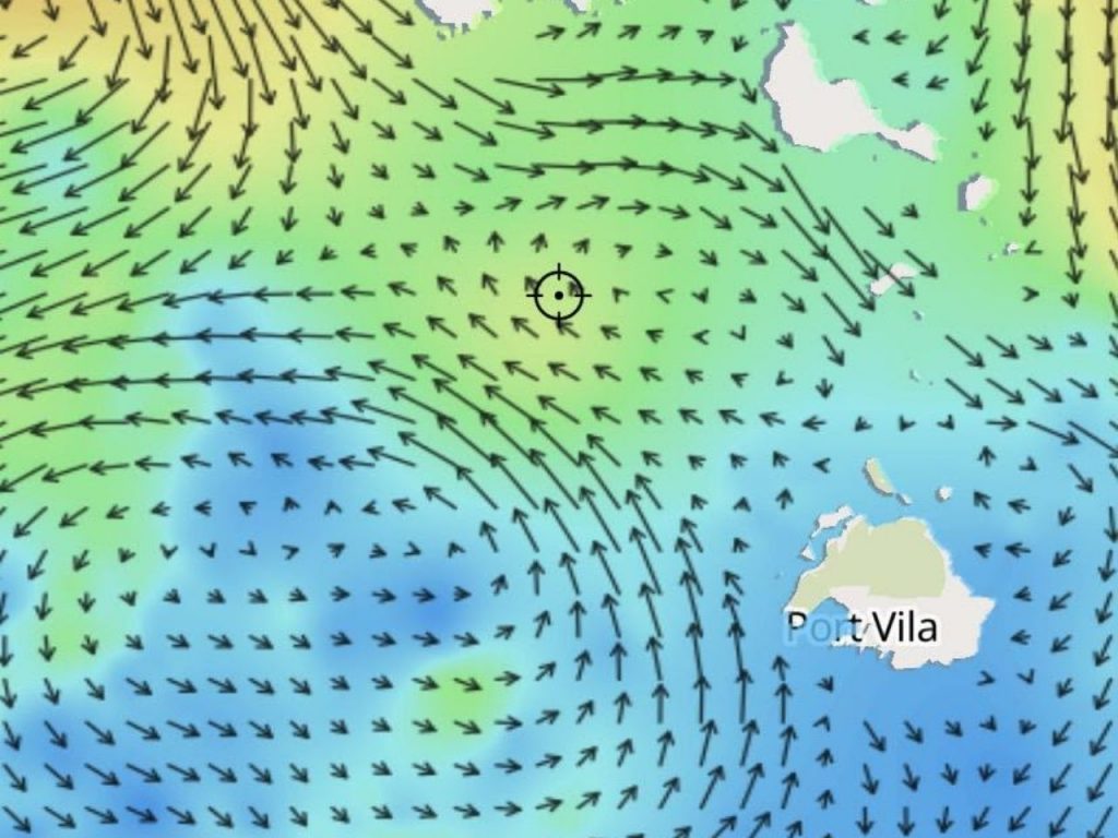
Surface current has a massive impact in how your fishing is going to turn out for the day. Personally, I think that if you are out to fish, you really do need some surface current. But you don’t want too much, as this will affect the schools of bait balling up.
For me, this is why sometimes you will have a lot of current on the surface and then you will be marking bait balls at 100m, plus I believe it to be a lesser undercurrent, these are only my thoughts not proven facts.
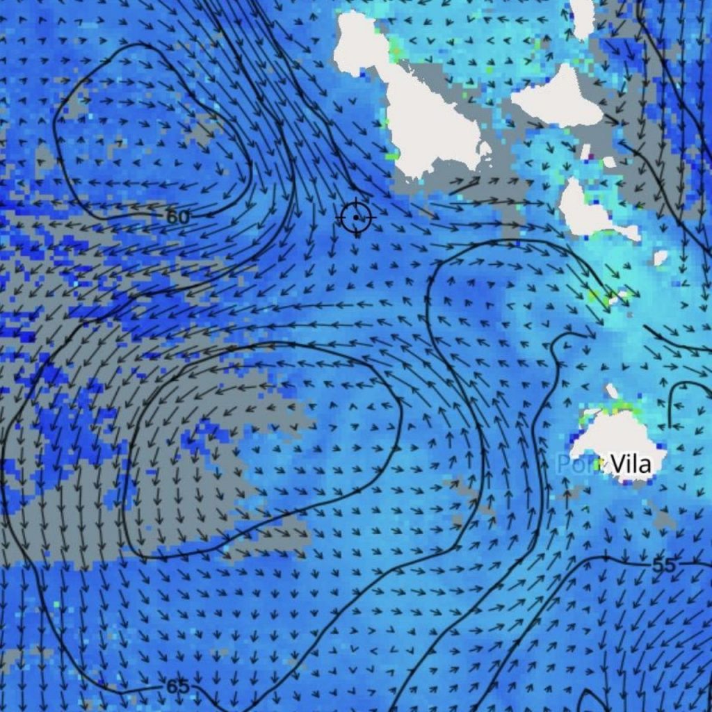
Sea surface height
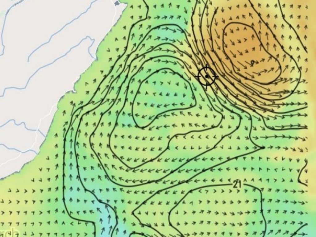
Altimetry or in simpler terms, sea surface height, is perhaps one of the biggest and most misunderstood factors that fishos can take advantage of. If you aren’t sure what I’m talking about, I’m talking about the physical height of the water in the “up and down wellings.” It’s confusing as hell, so let’s try to make it as easy to understand as possible.
When you look at the water surface, you will be able to spot this ‘anomaly’ as a contour of sorts that looks like small, watery hills. Within these, there are up and down wellings and a vortex. Somewhere inside, there’s a “fish freeway,” which is, of course, what we’re interested in.
To understand it better, let’s check them one by one.
- Upwelling
An upwelling is a large eddy that turns clockwise. This is the direction where it will be pushing the water up. To put it simply, an upwelling is the areas of the water which is generally cooler, as it is pushing the colder water up to the sea surface.
- Downwelling
Conversely, when we talk about downwelling, we are actually talking about the water eddying in a counter clockwise direction. This is the area where the physical height of the water surface is lower than the referenced mean surface height. There’s a vortex that draws in the warmer surface water and pushes it down, creating a patch of water down to the depths. This is what is meant when people discuss sea surface heights.
- Fish freeway
This is what we’re interested in, as it is the fishiest part of the water. Now to find this, you’d want to find the water area that runs in-between the up and down wellings. This area has zero altimetry, which makes it the area with the least resistance. You’d want to fish within a mile or so on either side of the zero line, as this is the extent of this “fish freeway.”
Now that you have an understanding of sea surface heights, forget trying to figure it out visually. There are apps that are readily available like Fishtrack, Ripcharts and Timezero and they offer satellite imagery to identify these fishing hotspots.
Water temperature
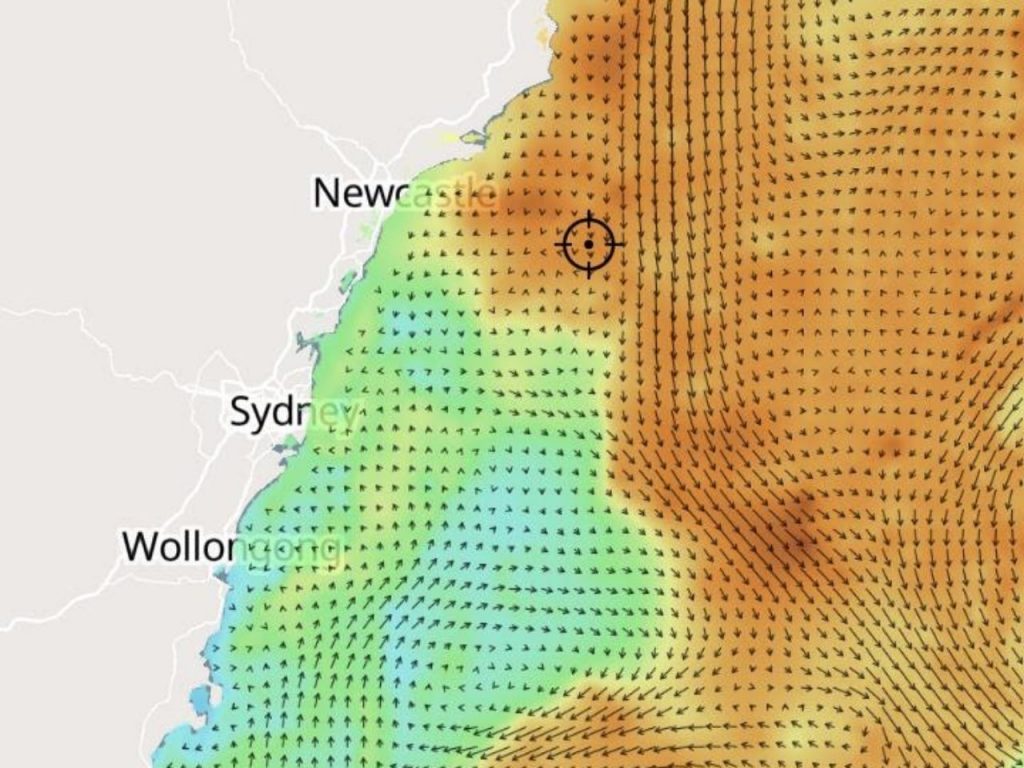
Water temperature plays a major role in whether the fish are going to bite or not, and this is where knowing your seasons and the average water temperature for each come into play.
First, most fish can’t regulate their body temperature. Because colder temperatures make them sluggish and warmer waters make them more active, they tend to adjust their metabolism and food intake. Simply put, your lures and baits become more appealing in warmer conditions because they need to feed more to survive.
But, there’s more. The amount of dissolved oxygen that fish need to breathe in the water varies depending on the temperature. The rule of thumb is, the colder the water, the more dissolved oxygen there is.
Simply put, depending on fish species, there’s a specific water temperature under which the fish won’t feed, and a maximum water temperature over which it can’t breathe. As a fisherman, you only need to know where and when they need to feed.
There are apps that you can use to check sea surface temps, but the best information is that you get real-time. Nearly all transducers have built-in technology to read the water temperature, and they are pretty damn accurate. It doesn’t take much of a change to take some time to find where the fish are feeding and it is a great weapon to have in your arsenal if you are targeting yellowfin or marlin.
RELATED: Simrad NSS EVO3S First Impressions: What’s New?
Chlorophyll
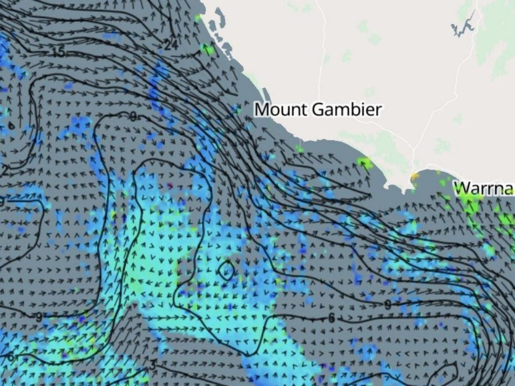
Chlorophyll is yet another important factor you’d want to check before you get on that fishing trip. It refers to either in-app chlorophyll filters or chlorophyll charts. These filters and charts mark the places where the ocean’s plants, Phytoplankton, grow.
It is easy enough to find the Phytoplanktons. You also don’t need to know more details about it, except that the fishing ecosystem develops and thrives where there are large concentrations of chlorophyll. After all, “Phytoplanktons” are at the base of the food chain that the rest of us, and even the fish follow. Simply put, “phytoplanktons” keep the smaller fish alive, so the bonito can eat them, and the yellowfin can eat the bonito and so on.
Note that while following the chlorophyll can sometimes lead to productive trips, there are instances when these areas turn out to be devoid of life, especially after heavy or flooding rain.
Final thoughts
A Barometer, barometric pressure, sea surface currents, temperature, chlorophyll concentration, and even altimetry can be really useful if you wish for an efficient and productive fishing trip.
True, there are all sorts of tools that are now available to help you be better fishermen, but at the end of the day it’s being able to factor in all these elements and cross-checking it with what you are seeing that is most important. After all, fishing still runs on instincts, much like it did at the time of our hunter-gatherer ancestors.

